Tuesday, February 4, 2014

Grotto's and Big Morongo

The Grottos is a slotted canyon that has been filled with giant boulders to form a cave system. It was two years ago that I hiked through them and as always they had changed and created some new challenges.  We had a great day and we started out an hour earlier so we wouldn't be hiking in the heat of the day.

This is the group all fresh after hiking up to the first ridge and lookout.

There were a few Ocotillo with a few blooms but with no rain this was very rare.

You could almost taste the dryness in the air, even with out the dust.

The water in this wash area made area almost like a cathedral. Below photo I am standing inside the feature.


We walked through a maze of large boulders off the main wash to reveal a hidden spring.

We climbed another ridge after the hidden spring and this ridge would take us to the far end of the canyon where the grotto was awaiting us.

The edge was a bit close as we followed the trail.

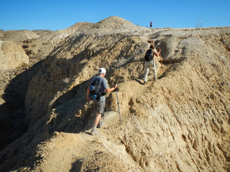
As I mentioned above the trail was a bit close to the edge...

Entering the top of the grotto

The challenge was to climb the boulders inside the cave.


Did we say the boulders were giant? 

There is always someone wanting to explore more of the caves... right Bob?

This the crew near the first ridge. No one is standing now... Not quite the same spring in their step. 


Big Morongo is a preserve that changes quite a bit with the seasons.  Winter is a time for many plants to be dormant as well as fewer birds.  We shared the hike with about 25 birders so the birds must be out there but we don't have the skills to track the source of all the bird songs.

Our trail is some where to the south through this valley.

The trails in the preserve are very easy to follow and they also provide a map that make even first time hikers feel safe from getting lost.

A surprise to see plants in bloom. This one is a 'Bladder Pod'

These plants are 'Apricot or Desert Mallow'

The preserve had an abundance of these plants. Yerba Santa

Colorful blend of vegetation down in the swamp area

This Scrub Jay was looking for handouts as always...

Spring is in the air and in the trees with early blooms in this willow type tree.

Sunday, January 26, 2014

Palm Canyon Trail and Whitewater Ridge

Palm Canyon Trail is located in the Indian Canyons - Agua Caliente Indian Reservation.  The trail is over 15 miles long but we took a portion of the trail that connects to another trail (East Fork) and made a loop of about 6.5 miles.  

The trail navigates around a ridge that is cut by a wash along the east fork.  It was good fun scaling the short rock outcrops in the center of the canyon.  The views of the fan palms lining the bottom of the canyon was stunning and then when we worked our way to the top of the wash we were greeted by a view of the San Jacinto mountains.


Great views open up at every turn of the trail

Many different rock formations create the walls of the canyon

One of many rock faces we scaled.  There were side trails that would skirt some of theses features but scaling the rocks was more fun and quite safe.

Doesn't look high from this angle but from above it is looks steeper.


First view of the mountains

The open plain at the back of the ridge

Trail on the way back to the trail head

The trail follows the base of the fan palms

Silhouette of palms standing sentry over the canyon below. 

The second hike was back to the Whitewater Preserve and we had a sky of partial cloud that added to the beauty of our hike as well as made it much cooler when out in the open sunlight.


View along the ridge makes this hike the most popular in the preserve.


This vine like all vines were dominating the surrounding plants by using them as a trellis.

This shrub had only a few vibrant yellow blooms that stood out against the very dry bush behind them.

The other half of our group zig-zagging down from the top of the ridge trail.

Some of the trail dissected the Pacific Crest Trail - Canada is only 2445.4 miles away on this trail.  Looks like it would be easier to go south to Mexico.

It is always fun to visit the hatchery at the end of the hike. I stuck my camera under the water and they swam close by thinking I was offering them food.

Monday, January 20, 2014

Hell Hole Canyon Loop - Utah Canyon

Hell Hole Canyon is the first hike down the valley towards Mexico. It is just out of the town Borrego Springs and is in the Anza- Borrego Desert State Park.  We were wondering how the trail got it's name but after about an hour of hiking we realized it was a bit of a hell hole with huge boulders to navigate around and of course any vegetation that grows has barbs that attract clothing and exposed flesh.

Early morning sunshine on the cholla spines

The sign over the fake graves "They didn't bring enough water"

There must be more rain in this area. The plants all had some blooms.


Don't kick the cactus they stay with you.


View looking up into the canyon

View looking across the Borrego Plain

Further up the canyon and the boulders are starting to grow

And bigger boulders

Fan Palms were growing all the way up the canyon and stopped just past the falls.

The boulders keep getting bigger and we had to pick our way through them.  The brush was growing up all around the trails and it made navigating a trail painful with all the barbs in all the plants.


The rock had some interesting combinations of stone.


I think by the expression he was saying "How did you get up there?"

There was no shortage of rocks to climb and get a vantage point.

Maidenhair Falls in all her glory... not much water.

Starting to climb out of the valley


Lunch break and time to talk about our war wounds climbing through the "Hell Hole"

The upper ridge at the top of the canyon looks a bit like a moonscape

A sign post at the top of the canyon.  There was a look out accessible by wheelchair and a parking lot just a 1/4 mile down a trail.  I guess we just had to do this the toughest way possible.
Nice view of the valley below.

Still more rocks stacked up on the way down.

I think this a patch of wild cucumbers?


The second hike was back to the Mecca Hills to try the Utah Canyon. It was named after the Utah rock formations a it resembles some of the colourful canyons of southern Utah.


Very narrow in spots as well

As we hiked further in the rocks from flooding were exposed and made hiking more difficult.

The views were spectacular at the end of the trail.


The colour on the way back down was good even in the early afternoon sun