Thursday, January 26, 2012

2012 - Coachella Valley Preserve Re-Visited

The Coachella Valley Preserve has a collection of trails and oases that occupy the eastern side of valley and area that lies along the San Andreas Fault. There is a visitor center that has many photos of recent and pioneer history as well as many pictures of the wildlife you can expect to see.  They have a website www.coachellavalleypreserve.org that has many of the same photos.

Our group hike out to McCallum Grove and pond and then walked a short loop trail south of the visitor center (smoke tree ranch) to visit a site of a palm tree fire from 2004.  It was very impressive how much the trees have recovered.  The hike was an easy 2.25 mile adventure.

Grove surrounding the visitors center

An unfortunate Side-Blotched Lizard that has had it's tail removed by a predator.  The tail will regrow.

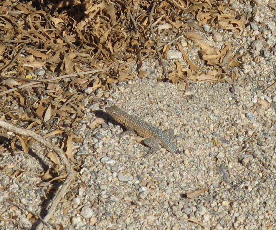
Lizards are very well coloured for hiding in their habitat.

I had fun with the hiking group as they were asked to rub the branches between their fingers and have a smell.  Roquefort cheese was the consensus which is why this bush is called the 'Cheesebush'.

A very dry trail leading to the McCallum Grove

Ocotillo in bloom and a close-up below of the plant's protection system


McCallum Grove and pond

We spotted a nest in the side of one of the fan palms and after talking to the host at the visitor center we think it belongs to a Great Horned Owl that has taken up residence at the grove.

A shot looking up through the grove's canopy.

This is a stump of the fan palm and you can see the fibrous rings that support the tree.  It is amazing to watch these tree in a wind storm and wonder how they don't break off. 

The Smoke Tree looks like a plume of smoke when you are a distance away but when you get up close you see it is a mass of thorns.

The trails close to the visitor center are right on the fault line and have water running through the area.  The board walk saves the vegetation from being walked on as well as the hiker from the foul muck of decaying plant matter.

Young fan palms growing in the back drop of the surrounding hills.

Thursday, January 19, 2012

2012 - Joshua Tree - Barker Dam, Hidden Valley and Jumbo Rock

Joshua Tree is always a great place to visit and last year when we were here there was more moisture and the plants were in better shape.  This year the rain is almost nonexistent so it was interesting to see the changes that have taken place. 

The entrance to Hidden Valley was improved many years ago by a rancher named Keys who dynamited a larger opening so cattle could go through and today it works well for all the visitors too.


Great fence for cattle.


This Scrub Jay is usually very wary of prying eyes when it comes to his food cache.  He is eating what appears to be an acorn from a oak even though he is sitting under a pinion pine tree.  These birds have been known to have up to 200 food caches and are able to keep track of them.  Other Jays will often clean out  another bird's  cache.


Barker Dam had really changed from last February.  There was at least 6 feet of water at the dam face last year and this year not a drop.

January 2012

February 2011

This slab of rock has recently calved out of the center of this larger rock.  You can tell by the white colour of the rock that it was recent.

Dam - January 2012

Dam - February 2011

This red barked bush is called Manzanita (Mexican for Little Apples)  This bush was very healthy as it is drawing water from the base of a very large rock that stores water around it's base.

The hiking group stopped in at Jumbo Rock campground and had a picnic in one of the campsites.  This would be a great place to come and view the night sky and probably listen to the hungry coyotes howl.

The hikers split up here.  Some headed back early and a few stayed to hike towards these rocks in the Skull Rock area.  Sorry I didn't stay to take a photo of Skull Rock but there are a lot of pictures on the Goggle website.

Thursday, January 12, 2012

2012 - Whitewater Canyon Ridge Loop

The ridge loop hike was one of the hikes that we attempted last November and we missed the trail head so armed with new information we started out with 12 people and 3 dogs in our group.  My dog Chip was leading and he got us lost right away as we headed up an old burnt out trail. (have to blame it on someone)

Once we arrived at the top of the first ridge we ran out of trail but the new trail was easily found and we were off up to the top.  The trail was just over 3.5 miles long and the elevation gain was over 600 ft.  All the references say that it is an easy trail but most in our group were thinking that it was more effort than easy.

The views from the top of the ridge gave us a good appreciation for the force of water on the rock and vegetation down in the canyon.

View south toward Palm Springs

The Ranger Station is nestled in the greenery at the far side of the canyon.

I am not sure when this small fire happened but there was some evidence of plants coming back.

This zoomed-in view of San Jacinto mountains also shows part of the huge wind farm that overwhelms the pass coming into Palm Springs.

At the top of the ridge there is a fence to keep people to the left of the ridge.  The drop to the right is very sudden and is just out of view.


There were hundreds of Brittle Bush in the area but this one was the only one in bloom.

Ridge trail view looking north up the canyon.  There are three canyons and creeks that feed into the main canyon that makes up the Whitewater river.

This small evergreen is part of the coastal forest and ends on this side of the canyon.  The other side of the canyon totally different vegetation.

View of the pond at the ranger station.  This was the site of an old fish farm and there are still trout in the ponds.

My faithful dog Chip returning after checking out the small evergreens.

The zig-zag route down off the ridge was certainly steeper than the route up.

The route down was shaded enough so these ferns and grasses could survive.

Chip is leading the way down into the canyon.
Fording the river is made easy with these bridges.


This is one of the fish that gets to swim around in the ponds.  The only fishing allowed is when they run a special program for children.  This fish was at least 16 - 18 inches long.

Saturday, January 7, 2012

2012 - Big Morongo Canyon Preserve

The Preserve begins about one-half mile southeast of the town of Morongo Valley in the Little San Bernardino Mountains and opens at the bottom of Big Morongo Canyon into the west end of the Coachella Valley northwest of Desert Hot Springs. Elevations on the Preserve range from 600 feet on the canyon floor to over 3000 feet at the ridge tops. Several trails, including boardwalks through the marsh and stream habitats, meander through the Preserve. The one-half mile Marsh Trail is wheelchair-accessible.  The group hiked most of the trails covering a distance of about 3 miles.
The Preserve is open daily throughout the year--from 7:30 am to sunset--but the ideal months to visit are in the fall, winter, and spring seasons.  I asked a birder that was in the park and he said fall and spring were the best times.  For flowers and foliage I imagine the spring would be good.

Our hike was interesting considering the area was ravaged by fire in 2005.

View of San Jacinto mountain over the trail ridge.


View from Yucca Ridge looking down on Desert Willow and Marsh Trails.

A varied selection of desert plants grow on the ridge.

The town of Big Morongo in the foreground and San Gorgonio mountains in the background.

View of the Mesquite trail.

View down the canyon. At the far end of the photo the trail turns left and the canyon narrows. About 4 miles down the canyon it will intersect with a road going to the city of Desert Hot Springs.

Some evidence of restoration from the 2005 fire.

There was one steep hill.

On the bottom end of the marsh they had a great observation deck to rest and enjoy the view.