Friday, February 8, 2013

Pushawalla and Horseshoe Oases Loop

The hike this week was a bit more strenuous than some in our group would like and after looking at the profile I can see some of the hills are a bit abrupt to climb comfortably. I have never left anyone in the desert and we always wait until one's heart has return from their throat back to their chest.

The Pushawalla had a bit more water flowing through it and it seemed a bit greener than earlier in the season but there still isn't many flowers out in bloom.
This is the hike profile. Our hike started on the left side of the screen (165 m elevation) and finished at the right side at around 6.8 km in distance.
The hikes first ascent started with a set of stairs.

We thought the hike would have to be cancelled because of high winds in the valley  but they weren't too strong up here on the ridge.  As you can see the air quality was very poor in the valley.

The group descending the ridge.

This wash area is the only real ankle breaker on the hike and thankfully everyone was careful with their footing.

Pushawalla Palms

We stopped for a rest inside the palm grove and some of the group thought there was a bit of an unpleasant odour. After our break they looked over a small bank and found this poor old coyote.


Nice to see the creek was flowing.


Another hill... what goes down must go up... that is if you want a ride home.

Horseshoe Palms


The last hill to climb before we get to the cars. Great cardio workout


The stair are the last obstacle before the parking area.  Obstacle as they are about twice the height of any building code would allow.  You can hear your knee snap, crackle, pop and groan. 

Tuesday, February 5, 2013

Pyramid via Slot Canyon

On this hike we started to look for the Big Colorful Canyon and as we followed the instructions it didn't seem all that clear so we went by the GPS mileage and turned up a canyon that was exactly .25 miles from our parking area.  Just because it wasn't a wide canyon didn't matter.

We had a great hike and ended up exploring two slot canyons. The first canyon ended abruptly and it looked as if no one had attempted to climb out, but the next one looked very promising and we made it all the way to the top of a ridge.  

It was obvious that we weren't where we were meant to be so we dropped down into a canyon that was part of the Pyramid Canyon Trail.  It was very interesting to take this round-about-route...

Not the right opening for colorful canyon...


The scenery was spectacular and the path seemed wide.


The first slot canyon came to an end and I didn't want to scale the falls.

Always seems to be lots of lizards around.


Lots of rock/sand blocks that have calved off the side of the canyon.

Some of the rocks are suspended and form a cave where we had to crawl through.


The last slot canyon we climbed the waterfall and came out near the top of a ridge.

Thanks to Arick for supply some pictures.

We got great cell reception up here too.

Brittle Bush is starting to bloom after last week's rain.

We thought we saw a pyramid straight ahead.


It was more obvious looking at it from the east side.


There are many rock formations that reminded me of Arizona.


Monday, February 4, 2013

Whitewater After Some Rain

First hike after the rain that we have had produced  a bit of a change in the hike at Whitewater.  The road had a bit of water going over the top instead of underneath but other than that it was a clear day and we had great views.


Only a few people got wet feet walking through.

No wild animals just a bit of flooding


Nice view except for the smog


Rock outcrop ran along the top of the ridge


The river below was running hard enough that you could hear the noise.
The trail had switchbacks to get off the ridge.


Joking around with trail junction... seems one of the team wants to go the opposite way.


Tested out my camera for underwater photos love the effect.

Hungry fish - a leaf fell into the pool and they came right over to check if it was food.

Saturday, January 26, 2013

Ancient Lake Cahuilla - Fish Traps

Ancient Lake Cahuilla filled the Imperial Valley from the Colorado River Delta in Mexico north to Indio. It is thought to have reached a depth of 300 feet. This fresh water lake would have been six times the size of the current Salton Sea.  I was reminded of this site by an article about Earthcaches http://earthcache.org/ on the Geocaching newsletter.

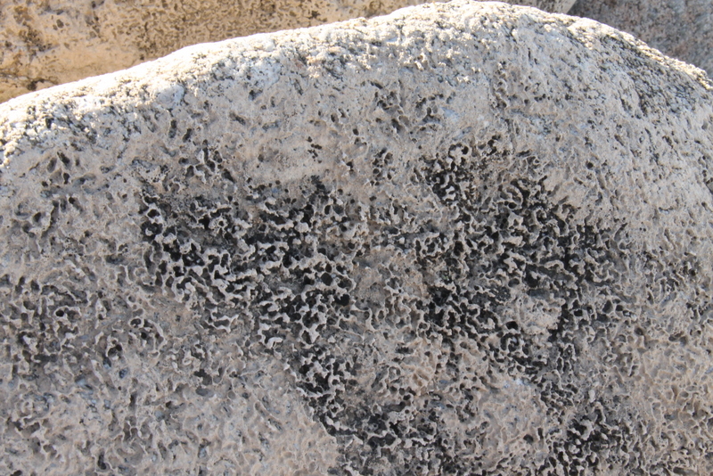
Evidence of the shore line can be seen today at the southeastern edge of Indio.  The water level was about 40 feet deep at this point.  The rocks below the old waterline are covered by travertine deposits.  Travertine, sometimes called tufa, is a freshwater lime deposit.  It is formed in waters that have a lot of calcium carbonate (what makes up shells) and algae. The algae uses the carbon dioxide from the calcium carbonate in photosynthesis leaving the lime.

Evidence of Lake Cahuilla's gradual evaporation can also be seen at the coordinates. In this case the evidence comes from what archaeologists have interpreted to be Native American fish traps. These traps are roughly circular piles of rocks that were built along the shore of the lake. Fish would swim into the circle and have a hard time figuring out which way to swim back out of them.

The coordinates bring you to a line of traps built along the hillside at about the same elevation. If the archaeologist's interpretation of the rock piles are correct, the shoreline of the lake would have been at this elevation at the time these traps were used. As you can see these traps are below the high water mark shown by the presence of travertine on the rocks.

A little investigation around the coordinates and you can find other lines of traps at different elevations. The interpretation is that as the lake level fell due to evaporation, another set of fish traps would have to be made since the traps at the higher elevation would no longer be in the water and would be useless as fish traps.


Water level indicated by the ring of colour on the surrounding hills.  It is similar to the ring kid's leave on a bathtub after playing outside all day.


Newer fish trap

Travertine deposits

It is easier to see the pattern fish traps from above.

Travertine deposits can be over  1/2 inch thick.

Older fish trap higher up on the hill side.