Thursday, November 28, 2013

Horse Thief Creek and Big Morongo Preserve

These two hike are as far apart in the valley as you can get.  Horse Thief Creek is to the west up on a mountain pass in the Santa Rosa range that leads to Los Angeles and the other trail is to the east at the entrance to the San Bernardino Mountains. 

November is the last month to get some fall scenes as well as an opportunity to see some birds.  As winter approaches some birds and greenery disappear.  

Horse Thief Creek Trail is covered in chaparral (shrub land or heath) and slices through rugged canyons.  It is a 5 mile trip in and out with many hills and valleys to hike up and down.

Prickly-Pear Cactus among the rocks

Rain water and traffic have beaten this trail up.

This agave plant is possibly a century plant as it is very tall and the leaves appear to be dying.  The plant lives from 10 - 30 years and dies after it flowers.  A new plant will grow as a sucker from it's roots.

The scrub oak has many of these orbs on their limbs.  I believe they are acorns that have been bored into by insects and used as a nursery for their eggs. This one is about 1 1/2 inches across.

It is interesting how this tree is both alive and dead at the same time.

Horse Thief Creek Canyon


Agave close-up

California Fuchsia graced the side of the trail where there was some partial shade. 

Prickly-Pear Jungle?

 Our second hike, Big Morongo Preserve located in the Morongo Canyon has been visited by many birds and animals.  Fires have occurred here quite often and you can see how the native plants have tried to grow back.  One of the unique features of the preserve is the changes of vegetation with the elevation changes.


A Scrub Jay perches over our heads in a Mesquite tree.  He is hoping for a handout. 

View of the marsh area from the upper trail shows just how dramatic the vegetation changes.

A 4 + mile Canyon trail starts at the top end of this photo. 

Our hike took us around the hill and along the marsh area.

View from back of the hill looking to the community of Morongo Valley

Mesquite trees and shrubs slowly growing back in a burned out hillside.

This area is covered with alkali goldenbush, a dominant perennial shrub that gradually replaced non-native weeds after a fire in 1992.


Tuesday, November 19, 2013

Berdoo Camp and Horseshoe/Hidden Oasis

The first hike of the week was just a small trek up an old paved and washed out road to Berdoo Camp, a ghost town.  This camp was set up in the 1930's and was used to construct the Colorado River Aqueduct. The shaft or adit goes in from this site over 2000 feet. This camp was responsible for the construction of 5 1/2 miles of tunnel. The road that passes by the camp is used by 4 wheel drives to access Joshua Tree National Park.

The road below the camp is used for a firing range and strewn with empty cartridges, shot-up targets and garbage.

The hills in the center are a level platform where the tailing from the tunnel were dumped.

Not sure what kind of bug was running around here but is had what looked like a fuzzy sack attached to it's back end.

Good to have Brian back hiking with us this year...

Photo looking out to the Coachella Valley from the center of town...

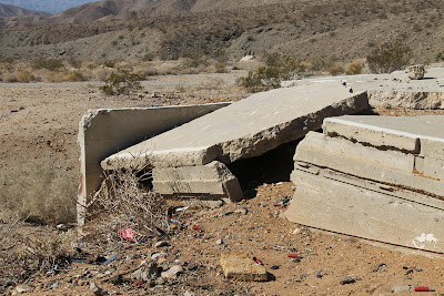
The foundations have certainly crumbled over the years


In this photo I have sketched around where the shaft opening was and also where a trestle was located.

View up the canyon and the way to Joshua Tree Park

There are a few companies that offer 4 X 4 tours through this back road. I don't know if they provide a kidney belt but the paved roads must feel very smooth after 24 miles of this.
The second hike of the week was to Horseshoe and then Hidden Oasis.  This hike is part of the Coachella Preserve and is just under 5 miles long.  The day was very hot and I am sure it was at least 90 F out on the open trail.  The palms you see in the oasis are all California Fan Palms and are the only naturally occurring palms in the state.  They are usually found in the center of a geological fault line. 

This oasis is along the San Andreas Fault

We walked the ridge above the Horseshoe Oasis

Our hiking group at the eastern end of the Horseshoe Oasis

A view over the cliff of the bottom end of the Pushawalla Oasis


Picture of the center of the Hidden Oasis as you will see below it is hidden when you walk on the trail but if you drive up Washington Avenue from Indio you will see the oasis from the road.

The oasis is just around the corner to the left but the main reason for the picture is to show the air quality when the wind blows all the sand around.  Anyway, hope it is sand and not smog.

A parting shot of Indian Palms in the distance before we head back down the hill to the car.

Sunday, November 10, 2013

2013 - Winter Season Begins

Another Snowbird season has arrived and it seems that each year we get here a bit sooner.  This year we were here on the 26th October and three days later I was out on the Bump & Grind. It is named that because a section of the trail climbs about 800 feet in almost a scramble.  I took a small detour by mistake and ended up scrambling.  

I have had two other hikes, Garstin/Henderson and Whitewater/Red Dome.  The last one was the longest only because we hiked across the valley to find out where Whitewater River had gone. One of the tributaries had dried up.

The Garstin trail is quite steep and is used by many as a fitness trail as you can really get the heart beating going up the path.  I love to look into the subdivision at all the beautiful homes.

Love the property but the privacy from hikers might be an issue.

This lot is actually two with a beautiful garden on one.

North to Palm Springs

View of the lower part of Indian Canyon.  All the trails in the upper canyon are closed because of flood damage incurred during September rains. 

View of the airport, middle left of photo
Our next hike was to Whitewater Preserve and was certainly an easier hike as the elevation changes was only about 200 feet.  This is the first time I have hiked here when there was no water near the Red Dome.

Monarch butterflies are attracted to this blooming Rabbit Bush

Red Dome

Picture taken from the bottom of the dry river bed

We found the water on the other side of the valley but not a huge stream.

This picture shows the hills plunging into the valley making a very zig-zag course for the river.

We returned back to the preserve ranger station to find a group of students on tour of the old hatchery.  They had a great time feeding the fish.

Ranger Station